
I woke up early to buy food for breakfast, snacks, and lunch at the nearby convenience store before catching the first bus (bus 240 at 630AM) to Yeongsil Ticket Office of Hallasan. Upon arriving at Yeongsil Ticket Office, I asked for a map then started on my warm up: a 2.5-kilometer uphill walk (on concrete sidewalk) from the Ticket Office to the trailhead. The signs to watch out for snakes and boars every hundred or so meters made me wonder what I would do if I ever encountered one or both of them. I drew a blank. Thankfully, not a snake or a boar stopped for a chat. Nor any car. Many cars zoomed past. One slowed down and looked at me, but did not stop to offer a ride. Maybe he saw I was not Korean and did not know how to offer a ride in English? I would like to think so. Had he offered a ride, I would have gladly accepted it to conserve my energy for the official hike ahead.
 |
| Yeongsil Trail (Click to enlarge) |
Reaching the stone engraved with "1280masl," I was officially at the trailhead of Yeongsil. The trail began in a wooded area for a few hundred meters, then the "A Grade [Difficult]" section. The "difficult" section did not involve ropes or scrambling, nor was it very steep. The section started to incline with flat stone steps that then later on gave way to seemingly endless wooden stairs through open area (without any trees to provide shade). It was indeed a long climb on stairs and, in some sections, on steps made of rock. But the 360-degree view was so beautiful that I always had an excuse to stop and take a breather.

Yeongsil Trail started off in a wooded area

Last bits of snow at the end of March

Stairway to heaven
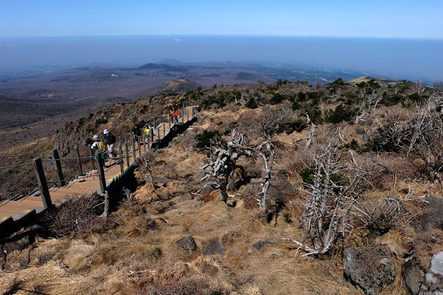

It continues on to the ridge

The B Grade [Normal] section of Yeongsil Trail

A rocky path to tread carefully on

The boardwalk branched off to the left and I took the turn and climbed some steps to the viewdeck on Witsejogeun Oreum.

At the Witsejogeun Oreum viewdeck
But this was not the end of Yeongsil Trail. I went back to the boardwalk and continued following the boardwalk to Witseoreum Shelter, carefully walking through snow-covered portions of the path.

To continue or not to continue


There were already many people at Witseoreum Shelter [1700masl], all of whom were sitting around, taking a break, and eating their packed lunches. I did the same. And ravens landed and slowly hopped towards me. I quickly moved away, afraid these black birds would steal my lunch.
After avoiding the ravens and eating my rather dry sandwich, I followed the snow-covered path to Nambyeok Bungijeom (Nambyeok Junction), but a few hundred meters of gingerly walking on slippery snow, I gave up and turned back. (I did not have the proper shoes for such conditions.)
I took the chance and took the Eorimok Trail. It started off easy: a gradual descent on a boardwalk, which went on for 1.5 kilometers, some areas still covered in snow.
 |
| Eorimok Trail (Click to enlarge) |

C Grade [Easy]

Looking back at the peak of Hallasan

Looking ahead....a long walk to Eorimok trailhead

Ugh, snow
Then the 800-meter B Grade [Normal] section of stony descent. Somewhere in this section, I overtook the two ladies and I didn't see anyone else ahead of me. The two ladies took their time and soon fell back and I was left all alone...not a soul in sight ahead or behind me.

The B Grade [Normal] section of Eorimok Trail


Uneven stones....walk carefully
The last section of my descent via Eorimok Trail was 2.4 kilometers of very uneven stony steps down through the woods. Portions of the path was covered in slippery snow. I had to step carefully while silently praying for safety. I did not want to slip and sprain my ankle as there was no one immediately ahead or behind me. I was ever so slow. One man eventually hurried past me and quickly disappeared down the path and behind the trees, and I was left alone again.


As I reached a bridge, I knew I was almost home free! Almost—because from Eorimok trailhead (970masl) down to the bus stop, it was another 10-minute walk. But an easy-peasy walk along a wood plank sidewalk compared to the rocky and slippery descent I had just been through.

Home free!
Important! Cut-off times for hiking (ascending and descending) Hallasan is imposed. The time will depend on the season. Best to start hiking early!
Directions by bus to Eorimok or Yeongsil: From Jeju Intercity Bus Terminal, take bus 240 to 어리목입구 Eorimok Entrance bus stop (40 minutes) or 영실매표소 Yeongsil Ticket Office bus stop (55 minutes).
This article is now available as a mobile app. Go to GPSmyCity to download the app for GPS-assisted travel directions to the attractions featured in this article.
South Korea Spring 2018
Jeju Accommodation: Sum Guesthouse Jeju Airport
Traveling Around Jeju by Bus
Checking out Cafes in Jeju
Jeju: Location, Location, Location (for a Photoshoot)
Jeju Eats
History and Nature in East Jeju
UNESCO World Heritage Sites in Jeju
Hiking Hallasan via Yeongsil and Eorimok Trails (you're here!)
Daegu International Airport to Gyeongju
Gyeongju Accommodation: Chacharang Guesthouse
UNESCO World Heritage: Gyeongju Historic Areas
Walking Around Gyeongju
UNESCO World Heritage: Gyeongju Yangdong Historic Village
Joining the Cherry Blossom Loving Crowds in Jinhae
Cherry Blossom Binge Continues in Busan
Busan Museum of Art
Spring 2018 Jeju and Southeast South Korea Itinerary and Expenses
hello
ReplyDeleteso which trail is the easier one?
Hello Pinoy Royalty. Yeongsil Trail is shorter, only 3.7 km up to Witseoreum Shelter; Eorimok Trail is 4.7 km up to the shelter. Please click on the trail maps posted above to check out each trail's grade/difficulty.
DeleteIn my opinion, Yeongsil Trail is easier in that most of it was stairs and boardwalks. Half of Eorimok Trail was uneven stony steps.
Hi !
ReplyDeleteI'm a little confused about the two bus stops (yeongsil ticket office and yeongsil entrance)
No matter what, I have to stop at the ticket office to pay the entrance fees and then go back to the yeongsil entrance to actually start the hike ?
Thanks for your help :)
Hi Sewey. You have to get off at the Yeongsil Ticket Office which is closer (well 2.5km closer) to the start of the trail. The Yeongsil entrance bus stop is at the entrance of the national park, not the trailhead. I hope that helps.
Delete