Friday, January 11, 2019

Finding Solace in the Midst of Seoul's Urban Jungle

One of the things I love about Seoul is that there are many parks around, providing solace (or should I say Seoulace?) from the hustle and bustle of the city. In past trips, I would visit a park or two for a specific reason: Yeouido Park in spring of 2012 for the cherry blossoms (but we were there a few days too early); Namsan Park in autumn of 2014 for the beautiful autumn leaves; and Songpa Naru Park for the cherry blossoms and Banpo Hangang Park for its Moonlight Rainbow Fountain show, both in spring of 2016. For my autumn 2018 trip, I went park hopping and I had reasons for choosing these parks.


Dream Forest Park
북서울 꿈의숲

Dream Forest Park, with an area of 660,000 sq. m., is Seoul's fourth largest park and is not frequented by tourists (or at least, that's what I read). The park is so big that there must be many reasons to visit. Indeed there are. Dream Forest Park has an observatory, an art center (with performance halls, an art gallery, cafe, restaurants), a children's gallery, different kinds of gardens, and an ancestral shrine. The main reasons why I decided to visit were the observatory and art gallery.

The Dream Forest Observatory, with a height of 49 meters, affords a view of the park, the city surrounding it, and the mountains beyond. The observatory is open from 10AM to 10PM and admission is free. To get to the observatory, I had to take elevators that go on an incline. It was a rainy day when I visited and the observatory was quite deserted—it was just me and two other visitors.

The art gallery in Dream Forest Art Center had interesting art pieces on display. It is free to enter and is open Tuesdays to Sundays from 10AM to 6PM.

A visit to the observatory and art gallery of Dream Forest Park on a rainy day would have been enough. But no, the rain could not stop me from venturing out to the rest of the park. The pond garden with Aewoljeong Pavilion was a pretty sight in autumn. Aside from the pavilion, it also had boardwalks and platforms for a view of the pond. The shrine on the east side of the park is called Changnyeongwigung Ancestral Shrine, which actually also includes a residence. The shrine (and residence) is designated as a cultural heritage. The shrine is dedicated to Princess Bokon (born 1818), the daughter of the 23rd king of the Joseon Dynasty.

Directions to Dream Forest Park: Take the subway to Miasageori Station. Take exit 3. Take bus #1124 (every 10 minutes) to Dream Forest Art Center Entrance bus stop. Bus fare is 1200 won.

Dream Forest Observatory

View from Dream Forest Observatory

Aewoljeong Pavilion

Changnyeongwigung Ancestral Shrine (and residence)


Oil Tank Culture Park
마포 문화비축기지

Oil Tank Culture Park? Oil tank? Yup, oil tank. This park has six huge oil tanks which used to hold enough petroleum to power Seoul for a month. It was in use from 1978 but closed down by the end of 2000 and was left abandoned until it was converted and opened into a park in 2017. Now the tanks hold a cafe, art exhibits, pop-up shops, an indoor performance hall, an open-air stage, and a museum about the history of the oil depot, instead of gazillions of petroleum.

I almost did not visit this park since—based on the few blogs I found about it—I had deemed it uninteresting. Because I had time to spare (yes, this was the only reason why I visited) I decided to drop by. My visit proved worthwhile, thanks to the fun art exhibits and pop-up shops that were there (and the fact that there were very few people in the park). It's all about timing, I guess.

Directions to Oil Tank Culture: Take the subway to World Cup Station Station. Take exit 2 and walk about 500 meters to Oil Tank Culture Park.

This tank contains a cafe, conference rooms, and lecture halls

One of the tanks is preserved

This tank has a performance hall (used for pop-up shops during my visit) and an outdoor stage

One of the tanks is a museum about the history of the oil depot

Inside the tank housing the museum

An art exhibit in one of the tanks


Haneul Park
하늘공원

Autumn is pampas grass season and this is the reason why Haneul Park was on my itinerary. Haneul Park has fields of pampas grass! It also has a uniquely shaped observatory in the middle of the pampas grass field.

On the southwest boundary of the park, there is a promenade that offers a view of Han River. An especially pretty sight at sunset.

What I did not know before I visited was that I would have to huff and puff up 291 steps to get to Haneul Park. On the upside (pun intended), the stairs gave an elevated view of another park across the road and of the city beyond.

For those who don't want a workout on the stairs, there is a shuttle bus (every 20-30 minutes; from 10AM to 6PM) that goes to three of the parks of World Cup Park (Haneul Park is one of the five parks that comprise World Cup Park). The fare for the shuttle bus is 2000 won one way or 3000 won roundtrip.

Directions to Haneul Park: Take the subway to World Cup Station Station. Take exit 2 and walk about 800 meters to Haneul Park.

Fields of pampas grass at Haneul Park


Han River at sunset

The view from the stairs


Naksan Park
낙산공원

Not to be confused with Namsan Park, Naksan Park is a small park on top of  Naksan Mountain. The Seoul City Wall is part of the park and is one of its main draws. (The Seoul City Wall, built in 1396, is 18.6 kilometers long built on the ridges of four mountains, one of which is Naksan Mountain.) The other main draw of Naksan Park is its sunset and night times views. And those two reasons were enough to warrant a visit from me.

Considering it is only 124 meters high, Naksan Mountain doesn't seem like a mountain, but walking to Naksan Park will be a workout. For people who like hiking, the walk to Naksan Park is just a warm up for the third reason to visit: Naksan Mountain Trail, a 2.1-kilometer hiking trail that follows the Seoul City Wall in Naksan and ends at Heunginjimun Gate, one of the four Great Gates of Seoul City Wall.

Directions to Naksan Park: Take the subway to Dongdaemun Station. Take exit 3. Take bus 종로03 (small green bus) to Naksan Park intersection bus stop.

Seoul City Wall in Naksan Park

The view from Naksan Park

Sunset

Bonus #1: If you're in Naksan Park, you can go to Marronnier Park 마로니에 공원 by taking the stairs on the north end of Naksan Park. The stairs will take you down to a quiet residential area, then to a busy area with shops, cafes, and restaurants, then to Marronnier Park which is surrounded by theaters. The park is small, more like a square, and there really isn't much to do....unless you're lucky, like we were! When we stumbled upon Marronnier Park, there was some kind of event going on and there were many local goodies for sale.

Bonus #2: From Naksan Park, you can also go to Ihwa Mural Village, a village with colorful murals. To get to Ihwa Mural Village, leave the park through its main entrance and take a right to Naksanseonggwakseo-gil. Follow the road until you see a rest area and stairs on your right. Go down the stairs to Ihwa Mural Village.


Yeouido Hangang Park
여의도한강공원

Yeouido Hangang Park is a park right along Han River. If you want to enjoy the breeze, have a picnic, take a walk or a bicycle ride (there are bikes for rent) along the river, or take the Han River Cruise, Yeuido Hangang Park is the place to go. (The Yeouido Cherry Blossom Festival takes place in Yeouido Hangang Park every spring, when the cherry blossoms bloom.)

The reason we went to Yeouido Hangang Park? Because my sister's friend kept bugging her to go see Han River. The park is about 3 kilometers long but we were too tired to walk the entire length since we used up all our energy the previous days. We just went for a look-see at the boardwalk and the I Seoul U sign.

Directions to Yeouido Hangang Park: Take the subway to Yeouido Station. Take exit 2 or 3.


Han River


Gyeongui Line Book Street
경의선책거리

Gyeongui Line Book Street. Did anyone say book? Anything that has to do with books, I am there!

Gyeongui Line Book Street. Street not park? It has green grass, trees, pathways, benches, book shops, book-themed art installations. Feels like a park to me!

On one part of Gyeongui Line Book Street (or Park!) is a section of an old railroad where they have built a platform with a small building and a signboard to make it look like a rail station.

Directions to Gyeongui Line Book Street: Take the subway to Hongik Station. Take exit 6.

Gyeongui Line Book Street


A section of an old railroad


Bonus #1: When you take exit 3 of Hongik Station, you can find a park called Gyeongui Line Forest Park in the middle of two roads. The park is 1.3 kilometers long with a stream running through its center and is lined by trees. In some parts of the park are preserved sections of an old railroad and old railroad signs.

Bonus #2: Near Gyeongui Line Forest Park is ArtPlatz 아트플라츠 연남, a cluster of colorful shops. ArtPlatz is along Seongmisan-ro 28-gil.

Colorful shops in ArtPlatz


Here's a map to help you find your way:

This article is now available as a mobile app. Go to GPSmyCity to download the app for GPS-assisted travel directions to the attractions featured in this article.

Sokcho+Seoul+Gwangju, Autumn 2018
Itinerary and Expenses: 10D/10N Seoul and Sokcho
Sokcho, Gangwon-do
Sokcho Accommodation: With U Hotel & Guesthouse
See Sokcho
Seoraksan National Park
Seoul
Seoul Accommodation: Hostel Tommy
Finding Solace in the Midst of Seoul's Urban Jungle (you're here!)
Art Museums in Seoul
Food for the Seoul
Unhyeongung Palace, Cheong Wa Dae, Jogyesa Temple
Gwangju, Gyeonggi-do
UNESCO World Heritage: Namhansanseong Fortress

Wednesday, January 9, 2019

Seoul Accommodation: Hostel Tommy

I stayed in different hostels/guesthouses on all my visits to Seoul, including this fourth visit. This time, my area of choice was Jongno-gu, where Jongmyo Shrine, Changdeokgung Palace, Insadong, and Gyeongbokgung Palace are.

I usually budget below 20,000 krw per night for a dorm bed. Since my sister, who would be joining me after a few days, chose a private room in Hostel Tommy, I thought it would be best to stay in the same hostel even if their dorm room is a little over what I would usually spend for a dorm, rather than transfer from another hostel.

66 Donhwamun-ro, Jongno-gu, Seoul

Location. Hostel Tommy was very easy to find. The stop for the airport bus is only a 5-minute walk from Hostel Tommy. The subway (Jongno3-ga Station) is only 200 meters from the hostel. Within a 10-minute walk are Jongmyo Shrine, Changdeokgung Palace, Insadong, Gyeongbokgung Palace, Unhyeongung, and Ikseon. There are convenience stores and restaurants nearby.

Hostel Tommy

Dorm Rooms. Hostel Tommy has a 2-bed male dorm and a 6-bed female dorm. The bunk bed has power outlets. Each bed has a pulldown shade for privacy. Each dorm room has its own dressing table with stool, mirror, and refrigerator. Each dorm room also has its own toilet and shower. Towel (handtowel size), soap, shampoo are provided.

Private Rooms. Single, double, triple, quad, and 4-/5-person family rooms are also available. Each room has an ensuite toilet and shower. Towel (handtowel size), soap, shampoo are provided. My sister and I stayed in a double room. The room had a dressing table, mirror, refrigerator, TV, hair dryer, rod with hangers, and coat hooks. The room was clean and the room size was perfect—there was enough room to move around even with the two cabin-sized suitcases and the table. It was not cramped at all.

Double room


Breakfast. Breakfast of bread with jam/peanut butter/nutella, eggs (cook your own), cereal, coffee, and tea is included in the room rate and is served daily from 8AM to 10AM. 

Common Room. The common room is brightly decorated and has PCs, games, TV, and cooking and eating utensils for guests to use. When the hostel is full (which is good for the hostel, of course) the common area can get crowded during breakfast. But then that would be a good time to meet and get to know the other guests.

Common Room

Laundry. The washing machine and dryer are free to use, guests only have to pay for laundry soap.

Staff. The staff can speak English and are helpful. Tommy, the owner, is very friendly.

Luggage Storage. Luggage can be left at the guesthouse if you arrive early or if your flight is still hours after check out. And I appreciate that they allowed me to leave my bags while I went to another city in between stays in Hostel Tommy.


Note: I failed to take photos during my stay. All photos grabbed from Hostel Tommy's booking.com page.


Monday, January 7, 2019

Seoraksan National Park

A visit to Sokcho City in Gangwon Province at the east coast of South Korea in autumn season is not complete without a visit to Seoraksan National Park. Seoraksan or Mount Seorak is popular for hiking especially when the leaves change colors.

Directions to Seoraksan from Sokcho City
From Sokcho Express Bus Terminal, walk 100m towards the traffic light on your right (when facing the road), cross the road, turn left 20m to the bus stop and take bus #7 or #7-1 (1400 won; 45 minutes) to Sogongwon Entrance bus stop 설악산소공원 (the last stop).

Admission Fee
At the entrance of Seoraksan National Park, one must pay the admission fee of 3500 won.

Activities in Seoraksan National Park
Hike, hike, hike!!! Seoraksan National Park covers a wide area and have, therefore, many trails. In the eastern portion of Seoraksan National Park called Oeseorak or Outer Seorak (a portion of which is a part of Sokcho City), there are a variety of trails from short 1-day (few hours) hikes to 2-day and 3-day hikes. The 1-day hiking trails at Oeseorak are:

  • Biryong Falls Course – 2.4 km, 50 minutes one way, trail grade C (bit of slope, low difficulty level)
  • Geumganggul Cave Course – 3.6 km, 1 hour 40 minutes one way, trail grade C
  • Yangpok Course – 6 km, 3 hours 50 minutes one way, trail grade C
  • Ulsanbawi Rock Course –  3.8 km, 2 hours 20 minutes one way, trail grade B (slope is relatively severe and takes a long time)

If one doesn't like hiking, don't go to Seoraksan! Just kidding. At Oeseorak, there are less strenuous activities, too. The easiest activity, and most popular of all, is to take the Seoraksan Cable Car to Gwongeumseong. From the upper cable car station, it is just a 15-minute walk to the Gwongeumseong Fortress. The roundtrip ticket costs 10,000 won. Other activities are strolling around the park near the entrance and visiting Sinheungsa Temple, just a short walk from the park. And if one gets hungry, there are restaurants and cafes in the park and at the lower Seorak Cable Car station.

How I Spent My Day in Seoraksan National Park
The bus deposited me at Seoraksan National Park a little after 7AM, and before commencing my hike, I sat on a picnic table outside a restaurant (still closed at this early hour) to eat my convenience-store-bought breakfast. It was too cold outside, but, with a long hike up ahead, filling my stomach was more important than finding warmth. While I was eating (and shivering), an elderly man came up to me and remarked that it was too cold out and invited me in to the restaurant so I could eat my breakfast in warmth. I obliged and thanked him for his kindness.

Since it was too early to take the Seorak Cable Car (operating hours is from 9AM to 530PM) to Gwongeumseong, I didn't dillydally and started my hike to Ulsanbawi Rock. I figured I would take the cable car when I returned from my hike—if I still had time and energy by then.

The hike started easily through tree-lined pathways, across a bridge, and passing by a towering Buddha and three temples: Sinheungsa, Anyangam, Naewonam.


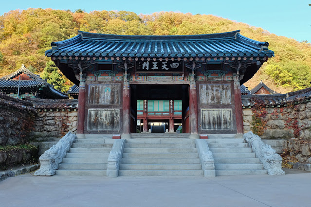
Sinheungsa


Anyangam


Naewonam

Then it was through the woods, where the path was clear in that it was a steel pathway over boulders switching to a plain old rocky pathway then to steps fashioned from rocks then transitioned to steel staircases. Some trees were already going bald, but some had just turned their colors. I even spotted a squirrel along the way.


A squirrel!

It was quite an easy walk and after about an hour, I reached Gyejoam Grotto. According to the information board, Gyejoam Grotto was built in 652! There is an hermitage built in the cave. And there is also a Logan or rocking stone which doesn't fall when pushed (maybe because it is too large and too heavy to be pushed!).


Gyejoam Grotto


Logan or rocking stone

Looking up from Gyejoam Grotto, I could see Ulsanbawi. Looks like I'm near! A signpost happily (if I signpost could) confirms and points the way to Ulsanbawi: 1 kilometer!

Looking up from Gyejoam Grotto, I could see Ulsanbawi


Almost there!

What the signpost did not tell me was that it was one kilometer of steep stairs. Whether steel or stone, it didn't make any difference—it was all steep and I huffed and puffed and stopped and caught my breath and huffed and puffed and stopped and caught my breath and on and on. Yup, the stairs were breathtaking, but so was the view. And the latter was what made me push myself to take another step (and the fact that it was too late to turn back).


I asked myself "Why am I here?"

I asked myself again and again...

...and again


The views made me push forward

Are we there yet?

I thought the stairs would never end. An ajumma overtook me on her hands and knees! She was crawling on the stairs but was way faster than me! I never did catch up with the ajumma, but in the end, we both reached our goal: Ulsanbawi Rock! (It was an easy climb in the sense that the trail was mostly stairs, but difficult in that it was a lot of stairs!)


Zoom in: Ulsanbawi


Zoom out: Ulsanbawi


I reached Ulsanbawi at 10AM (2.5 hours after I started). The sun was out, the sky was blue, there were clouds here and there, and the wind was blowing. Hard. The wind seemed intent on turning me into an ice cube! I had my camera with me but I whipped out my phone to take photos (and selfies) to send home...but in a few minutes it died. Stupid battery could not take the cold—it was probably close to 0°C whenever the wind blew.


Sokcho City as seen from Ulsanbawi

I went to every platform and observation deck available at the peak, and whenever the wind blew, I scuttled behind rocks. It wasn't long before I, myself, could not take the cold and decided to descend the mountain.

In two hours, I was back down at the trail head and made my way to the cable car station, where I saw an announcement that the next available ticket was for 2:35PM—and it was only 1PM! I didn't have anything else planned for the day and went ahead and bought myself a ticket. I killed time by having lunch at the restaurant in the cable car station, then roaming around the park, and, ultimately, just sitting and resting my tired feet.


Admiring the trees around the park


An hour and a half rest re-energized me (but not my cellphone's battery) and I was raring to go. The quick 5-minute cable car ride to the upper station afforded me a view of the mountainside awash in the pretty colors of autumn.


Cable car to Gwongeumseong


The view on that quick 5-minute cable car ride


Pretty autumn colors


The view from the upper cable car station

After that long and steep hike to Ulsanbawi, the 15-minute hike to Gwongeumseong Fortress from the upper cable car station was a breeze! When I got there, I forgot it was a fortress and forgot about looking for ruins. Instead, I was captivated by the sight of nearby peaks and the sun rays that squeezed their way in between.

Gwongeumseong Fortress


The sun tried to penetrate the thick clouds

My ears perked up when I heard some ladies speaking in Cebuano (my language). One said (in Cebuano), "Oh! It's so beautiful here! And that was an easy hike! I want to be a mountaineer when I go back home (to Cebu)!" And, thinking of my hike to Ulsanbawi earlier, I chuckled and thought: "Be careful what you wish for, friend!"


Sokcho+Seoul+Gwangju, Autumn 2018
Itinerary and Expenses: 10D/10N Seoul and Sokcho
Sokcho, Gangwon-do
Sokcho Accommodation: With U Hotel & Guesthouse
See Sokcho
Seoraksan National Park (you're here!)
Seoul
Seoul Accommodation: Hostel Tommy
Finding Solace in the Midst of Seoul's Urban Jungle
Art Museums in Seoul
Food for the Seoul
Unhyeongung Palace, Cheong Wa Dae, Jogyesa Temple
Gwangju, Gyeonggi-do
UNESCO World Heritage: Namhansanseong Fortress