Tuesday, October 23, 2018

Hokkaido Rail Pass

If you have plans to travel around Japan, from north to south, east to west, or just go around in circles, for a week (or two or three), the Japan Rail Pass is for you. But if you plan to travel just around Hokkaido, the Hokkaido Rail Pass is a "cheaper" (in quotation marks because, for me, both rail passes fall under the expensive category) option.

The Hokkaido Rail Pass offers four options: passes for 3/5/7 consecutive days or 4-day flexible pass (to be used on any four days within 10 days from the date of purchase). I opted for the 7-day pass for 24,000 yen. (Gulp! Expensive!)


With the Hokkaido Rail Pass, the pass holder can have unlimited rides on all the JR lines in Hokkaido within the validity period. The only exception is the Hokkaido Shinkansen which travels between Aomori and Hakodate.

An Exchange Order for the Hokkaido Rail Pass can be purchased before arriving in Japan (online or from designated travel agencies) or while in Japan (from designated JR East or JR Hokkaido Travel Centers) provided you have a "Temporary Visitor" sticker in your passport. The Exchange Order should then be exchanged for the Hokkaido Rail Pass at designated JR Hokkaido Travel Centers in Hokkaido only.

But to my surprise, when I purchased one at JR East Travel Service Center in Narita Terminal 2, they immediately gave me the Hokkaido Rail Pass (not the Exchange Order)! Good news for me. I could start exploring early the following day!

I traveled long distances almost daily to make the most of the pass. And booked a reserved seat whenever possible. Here's the list of JR train rides I took using the Hokkaido Rail Pass:


I rode 52,440 yen worth of JR train rides in seven days! That's more than twice the pass's worth! Yup, the Hokkaido Rail Pass was worth that big crater in my pocket!


Japanese Summer 2018
Otaru on Foot
Asahikawa Accommodation: Asahikawa Ride
Beautiful Nature in Biei Town
Lavender Fields in Nakafurano
Daisetsuzan National Park: A Short Hike in Asahidake
Shikotsu-Toya National Park: Hiking Thru Hell in Noboribetsu
Six Short Hours in Hakodate
Shikotsu-Toya National Park: Walking Through Abandoned Places in Toya
Hokkaido Rail Pass (you're here!)
Itinerary and Expenses: 9D/9N Hokkaido and Sawara Town

Sunday, October 21, 2018

Shikotsu-Toya National Park: Walking Through Abandoned Places in Toya

The last day in Hokkaido was supposed to be spent just exploring Sapporo. But I changed my mind before I went to sleep the night before. Sapporo, out. Lake Toya, in.

I took an almost-2-hour train ride from Sapporo Station to Toya Station, and at Toya Station I bought a roundtrip bus ticket (600 yen) to Toyako Onsen (roundtrip ticket can only be bought in the station; single journey fares—330 yen from Toya Station to Toyako Onsen Bus Terminal or vice versa—can be paid in the bus). The bus deposited me at the Toyako Onsen Bus Terminal, where, from the Information Center inside the terminal, I got some advice and some maps on what to see in the area.

When Mount Usu erupted on March 31, 2000, there were no fatalities or injuries, largely because of effective information circulation and cooperation of the people. The eruption did destroy buildings and roads, and created craters. To this day, abandoned and destroyed infrastructure, and the craters can still be seen along the Konpirayama Walking Trail and the Nishiyama Crater Walking Trail in Toya. And that's what I decided to go see in Lake Toya.

As I was walking from the bus terminal to the trail head, an Asian family followed me and the father happily asked if they could join me. Sure, I said. But when I told them I was going to go on a hike, they quickly changed their mind!

And so the lonely hike to abandoned places began.

I found my way to the trail head of Konpirayama Walking Trail, just behind the Toyako Visitor Center (the center has exhibits about the volcanic eruption, but I skipped that). From the observation platform at the trail head, I could see two buildings in the distance.

At the trail head

I followed the path to the buildings and as I got closer, I saw a bath house and an apartment building. Both in ruins. I was the only one on the trail and looking inside the broken windows and into the shadowy interiors gave me the creeps. Plants growing inside, rooms filled with soil, upturned and broken chairs, broken vending machines. Everything still. Yes, it was daylight, yet...creepy.

Bath house


Apartment Complex

I circled back to find trail marker T2. Following T2's gravel path, I continued on through an open area with some shrubs and trees, and at one point a nice view of the lake and the islands in the middle, then through thicker foliage.

Lake Toya and the islands in the center of the lake

The gravel path gave way to some portions of asphalt, which used to be National Highway Route 230. Trail marker T5 prompted me to turn right, leaving the asphalt road and back again into some overgrowth.


This section of the walking trail was mostly without tree cover and on loose soil. I took a left at trail marker T7 to check out the Yu-kun Crater. According to the information board (thankfully it had an English translation): "A building and a seismic station, that recorded eruption precursors, was now totally buried under the new tuff cone of Yu-kun crater."

Yu-kun Crater

At trail marker T8, I deliberately took the path with an X on my map because I am a rebel like that. I was curious what was there. Turns out it was a dead end: something gated and locked. Serves me right.

Back on the right path I went. I passed by a ruined building with a tall smokestack. And further, another old, abandoned building. A few dozen steps more and it was back to civilization: a parking lot with a car or two, a store selling snacks, a rest area. This was the end of Konpirayama Walking Trail.

Tall smokestack

And the beginning of Nishiyama Crater Walking Trail.

I took a snack break in the rest area, eating a sandwich I had brought along for this hike while gazing at the pond before me. A pond with the top half of electric poles and road signs sticking out. Underwater is a portion of Route 230, the same highway I came across earlier while walking along Konpirayama Walking Trail. I could see the road disappear in the water.

Route 230 underwater


Stomach refueled. Time to start hiking the Nishiyama Crater Trail. Just a few steps along, I see a man cooking some eggs. His egg-cooking area with a hand-painted sign, wooden tables, random chairs, a wooden shed with two wooden owls on top was a curious sight.

Eggs for sale

More curious though was up ahead: a road that had seemingly melted. Such was Mount Usu's wrath. From here the boardwalk ascends along the road up to the summit of 2000 Shinzan, "New Mountain" in English. This area was lifted 75 meters during the eruption of Mount Usu in 2000. From the summit, Toya and Uchiura Bay could be seen.


The summit of 2000 Shinzan affords a view of Toya and Uchiura Bay

I followed the boardwalk descending on the other side of the summit. I passed by remnants on the destruction: a rusty car in the undergrowth, a destroyed cookie factory, two abandoned and damaged houses, a portion of a tunnel.

A car that time forgot

The boardwalk ended, replaced by an asphalt pathway running parallel to the "melted" road. This pathway led me to another abandoned building. This time, a kindergarten. Where I found rusted buses, a dried pond, a rusty playground, toppled down signs, and a building with trees and plants poking through its shattered windows and missing wall panels.

This is the end of the Nishiyama Crater Tail and such a sad sight it was.

A damaged kindergarten

Plants growing inside

Rusty bus and rusty playground


From sadness to hunger, but I had no food left in my bag. I did not want to backtrack. I don't know how, but somehow I figured there'd be a bus stop somewhere up ahead and I just kept on walking. Yup, about a kilometer away, I found one. It took a bit of waiting under the summer sun (there was no waiting shed) before a green bus rumbled along to take me to Toya Station.


A little Japanecdote: Back at Toya Station, I asked the station master what time the next train to Sapporo was. He said 209PM, pointing at a timetable. I checked my watch, it was only 1226PM. "What about 1246PM?" I asked. "Already departed," he said. "It left early?" He looked at me incredulously. And that's when I noticed the clock at the station. It was already 130PM. My watch had slowed down for an hour!!!


Japanese Summer 2018
Otaru on Foot
Asahikawa Accommodation: Asahikawa Ride
Beautiful Nature in Biei Town
Lavender Fields in Nakafurano
Daisetsuzan National Park: A Short Hike in Asahidake
Shikotsu-Toya National Park: Hiking Thru Hell in Noboribetsu
Six Short Hours in Hakodate
Shikotsu-Toya National Park: Walking Through Abandoned Places in Toya (you're here!)
Hokkaido Rail Pass
Sawara Town
Narita Accommodation: Narita Sando Guesthouse
Itinerary and Expenses: 9D/9N Hokkaido and Sawara Town

Friday, October 19, 2018

Six Short Hours in Hakodate

6AM, the first express out of Sapporo to Hakodate. I don't remember much about the 3.5-hour train ride. I probably snoozed throughout the early morning journey.

The first thing I did upon arriving at Hakodate Station was look for the Hakodate Asaichi (Morning Market). Not because I was hungry, but because it was just a few steps from the station.

Squid on the manhole cover of Hakodate

The Morning Market is not just one big building, but a block of buildings. One building was mostly restaurants, another was for seafood, and another was a mix of fresh produce and seafood. I went inside the building with a tower and a sign: 駅二市場. Most of the stalls inside this building were selling fresh seafood. But there were also tables where people were eating brunch of whatever it was they had bought from the market stalls.

Inside 市場, one of the buildings in Hakodate Morning Market

Tram

The Kanemori Red Brick Warehouse is just a 15-minute walk from Hakodate Asaichi, but I was feeling lazy and took a tram (600 yen for a tram pass for unlimited rides good for one day). The brick buildings along the port of Hakodate were built in 1907. The buildings now house shops selling clothes, shoes, accessories, souvenirs, sweets, etc. In short, a mall.


 Kanemori Red Brick Warehouse

Although there were restaurants near Kanemori, I left the area to look for Ajisai, a ramen restaurant specializing in Hakodate's shio (salt) ramen. It was just a 4-minute walk from Kanemori. Ajisai was still closed when I got there (the restaurant opens at 11AM), but I was glad to be there early. Because as soon as I was seated, more people started coming in. This place must be really good!

 Shio ramen at Ajisai (860 yen)

I am a shoyu (soy sauce) ramen guy, but Ajisai's shio ramen was so delectable, I wished I had room for one more bowl.

Lunch over, I took the tram to go to the Motomachi District, where there are many historic buildings. The Motomachi District is located at the foot of Mount Hakodate, and up the slope I walked to visit the Former British Consulate of Hakodate (open from 9AM to 7PM; admission fee of 300 yen; a combo ticket for admission to both Former British Consulate and Old Public Hall is also available for 500 yen).

The British Consulate in Hakodate was established in 1859 when Hakodate Port was opened as an international trading port. The current building was built in 1913 and served as the British Consulate until 1934. During World War II it was used as a hospital facility. The building now serves as a memorial hall where visitors can see the rooms and some exhibits about the former consul and the opening of Hakodate Port.

 Former British Consulate of Hakodate

One of the rooms in the British Consulate

On the next block, up the slope, is Motomachi Park, where there is a mint green western-style building which used to be Hokkaido Government Office. It is now the Motomachi Information Center.

 Information Center at Motomachi Park

Behind Motomachi Park is the Former Hakodate Town Hall (open from 9AM to 7PM; admission fee of 300 yen; a combo ticket for admission to both Former British Consulate and Old Public Hall is also available for 500 yen). Since I had bought the combo ticket, I went to take a look inside the Town Hall. 

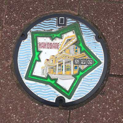
Former Hakodate Town Hall on the manhole cover

 Former Hakodate Town Hall

The huge Hakodate Town Hall, built in 1909 (and completed the following year), has two floors. On the ground floor are bedrooms, a dining room, a billiard room, and a banquet hall. On the second floor are the concert hall, and a few guest rooms. Members of the Imperial Family stayed here on their visits to Hakodate.


Also in Motomachi District are churches—Russian Orthodox Church, Motomachi Roman Catholic Church, and Hakodate St. John's Church—and many western-style residential buildings which made me feel I was not in Japan.

The Russian Orthodox Church on the manhole cover

 Russian Orthodox Church


 Motomachi Roman Catholic Church


Just two blocks from the Russian Orthodox Church is the Mount Hakodate Ropeway Station, where a cable car can take you to the top of Mount Hakodate. I read somewhere that the night time view from Mount Hakodate is great, but I did not read anything about views during day time, so I skipped that and, instead, took the tram east to Goryokaku Tower (open from 9AM to 6PM; admission fee of 900 yen).

Fort Goryokaku as seen from Goryokaku Tower

The Goryokaku Tower has two levels of observation decks. The first level is at 86 meters above ground, and the second level at 90 meters. The observations decks afford a view of the star-shaped Fort Goryokaku and the city of Hakodate. The second level observation deck does not merely exist for the view, but for learning about the history of the fort: there are dioramas depicting the history of the fort, a scaled model of the fort, etc. The first level has an exhibit about forts around the world, a souvenir shop, a cafe, an ice cream kiosk, and see-through floor panels (if you're afraid of heights, please don't look down).

 Diorama

Hakodate City as seen from Goryokaku Tower


Hakodate Magistrate's Office in Goryokaku Park

My reserved ticket for the express back to Sapporo was around 430PM and I didn't have time to visit the Fort and the Magistrate's Office located right in the center of it. Six hours sure went by too fast...


This article is now available as a mobile app. Go to GPSmyCity to download the app for GPS-assisted travel directions to the attractions featured in this article.


Japanese Summer 2018
Otaru on Foot
Asahikawa Accommodation: Asahikawa Ride
Beautiful Nature in Biei Town
Lavender Fields in Nakafurano
Daisetsuzan National Park: A Short Hike in Asahidake
Shikotsu-Toya National Park: Hiking Thru Hell in Noboribetsu
Six Short Hours in Hakodate (you're here!)
Shikotsu-Toya National Park: Walking Through Abandoned Places in Toya
Hokkaido Rail Pass
Itinerary and Expenses: 9D/9N Hokkaido and Sawara Town